Eben am Achensee, Tyrol, Austria
time : Sep 16, 2025 9:01 AM
duration : 8h 42m 8s
distance : 7.4 mi
total_ascent : 4747 ft
highest_point : 7974 ft
avg_speed : 1.1 mi/h
user_id : Nuernbergerchef1
user_firstname : Josef
user_lastname : Nuernberger
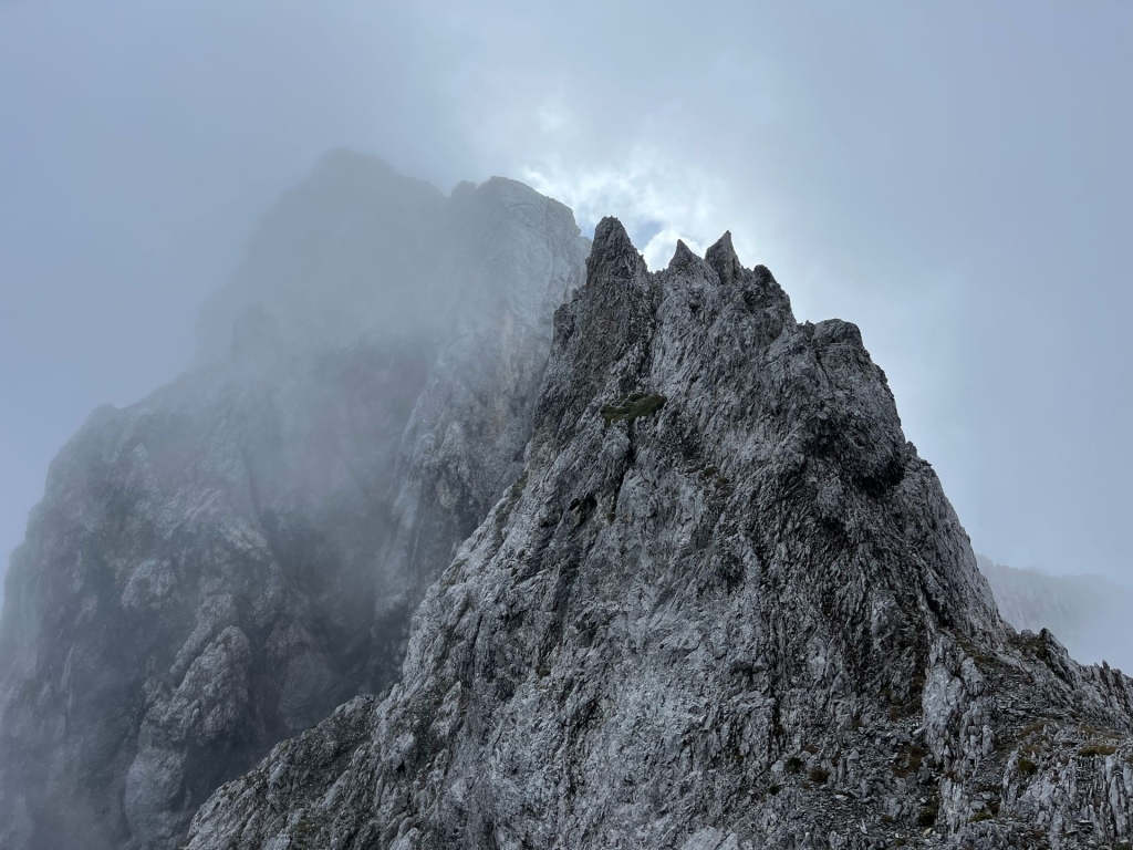
An Adventure for sure, Delayed my Hiking Start to 9:00 Am because of Heavy Rain as late as 5:00 Am, The first part of the Hike was an easy Road-walk up to the Stream Crossing. Was looking for the Cairn I had build on my Last attempt but didn’t locate it, Either way I knew my way and had my track from last time. A decent Path but steep and muddy today leading up into Falkenkar through Dwarf Pines, Neat-less to say I was soaking wet by the time I arrived. Visibility was very poor but I could make out a faint Scree Trail and a few occasional Cairns which I didn’t see last time in the Snow, Great I thought I am on a good way up and just went up the Ravine and was happy with my progress, ohh…, wait a minute, I haven’t seen a Cairn in a while and checked the Topo map realising I was in the wrong ravine and must have missed traversing further down, I was close up to the Ridgeline between Toten Falk and Turm Falk, somewhere I didn’t want to be but had to deal with now. Up was my only option to assess the Situation. According to the map I was very close to Toten Falk, barley could see the Summit through the Haze, In order to get to my Peak of the Day I had to scramble over Turm Falk First, This was not that easy with Low Visibility in loose Scree and quiet a bit of exposure. I am sure the Chamois on the Summit had been laughing at me traversing the last Ridge which to my Surprise had a Register Book in an Ammunition Box buried inside the Summit Cairn. With not much to see it was just trial and error along the Ridgeline to get down into the saddle with Laliderer Falk. (Where I was suppose to be all along). Scrambling along the Ridgeline took me forever but eventually I got into the saddle and going become much easier with no exposure but very loose Scree which is not fun either at least it was not dangerous anymore, Upon reaching the Summit or so I thought I realised that I was still a couple of hundred feet away from the Summit. Looking careful around I noticed a faint scree path going down, not knowing what’s awaiting me and whola I found a Cairn again, I was relived and happy to be somewhere near a correct path which wasn’t the case the past hour or so. A few more steep Scrambling Sections and more Cairns got me to the Summit. Summit Register, Cairn, and Trigpoint mark the Highpoint. Since the View was none I headed back down to the Saddle, now I had to search for a way down, initially a faint path and cairns mark the way but soon I lost that as well, It was all new terrain to me as I had only my ascent track and was trying to connect by traversing further down, Steep, Loose Scree, Wet Grass and everything you don’t need on traversing exposed terrain, I could see the Faint Scree Trail from my Morning ascent but getting down there was tedious to say the least. Eventually I made it down and connected with my Ascent Route, The Dwarf Pine Alley had almost dried out and it was actually quite fast to get back down to the Road leading to the Parking Lot. To summ it up, not a Bad Peak if you have Good Conditions.